


Cross's Map of London print
Couldn't load pickup availability
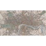
This colourful map created in 1844 shows Victorian London, as Charles Dickens would have experienced it. The detailed map presents from Kensington Gardens in the West to the West India Docks in the East, and from Victoria Park in the north to Millbank in the South. Locations and landmarks featured include Penitentary House, Vauxhall Station, Westminster Scholars Garden, Constitution Hill in Green Park, Buckingham Palace, Earl's Court, Primrose Hill, Chalk Farm, Drunken Dock, Dog & Duck stairs. BL Maps Crace VII/254.
Creator: Cross
Small 30cm x 40cm
Medium 45cm x 60cm
Large 60cm x 80cm
Extra large 75cmx 100cm
Please note the sizes above refer to the paper size, the image size will be smaller.
We are able to process UK and international orders for custom prints, with the exception of Europe.
Custom prints are not eligible for free shipping.
UK Orders
|
Custom Print Type |
UK Shipping |
Timescale |
|
Unframed Custom Print |
£8 |
5-7 Business Days |
|
Framed Custom Print |
£12.50 |
21 Business Days* |
North America
Important Notice: Temporary Suspension of U.S. Shipping
|
Custom Print Type |
North American Shipping |
Timescale |
|
Unframed Custom Print |
£20 |
15+ Business Days |
Rest of the World
|
Custom Print Type |
ROW Shipping |
Timescale |
|
Unframed Custom Print |
£25 |
15+ Business Days |
Unframed prints are shipped within 5 working days.
Framed orders are shipped within 20 working days.
As these products are made to order, we do not offer refunds on custom prints unless they are faulty or we have made an error.
For more information about custom prints please visit our FAQ's.