


John Rocque's Map of London print, 1745 Edition
Couldn't load pickup availability
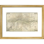
A historic map of 18th century London created by John Rocque. The text reads: A plan of the cities of London and Westminster, the borough of Southwark, and the contiguous buildings: with all the new roads that have been ,ade on account of Westminster Bridge, and the new buildings and alterations to the present year MDCCLV. Engraved from an actual survey made by John Rocque. This plan extends from East to West near six miles, and from North to South a little more than three, and contacins abiut 11500 acres of ground. Locations marked on the key include Aldgate, St George's Hospital, Skinners Alms-House, Mile End, the Exchequer, House of Commons, Court of Request, House of Lords, Mary le Bone Church, Westminster Infirmery.
Creator: John Rocque
Small 30cm x 40cm
Medium 45cm x 60cm
Large 60cm x 80cm
Extra large 75cmx 100cm
Please note the sizes above refer to the paper size, the image size will be smaller.
We are able to process UK and international orders for custom prints, with the exception of Europe.
Custom prints are not eligible for free shipping.
UK Orders
|
Custom Print Type |
UK Shipping |
Timescale |
|
Unframed Custom Print |
£8 |
5-7 Business Days |
|
Framed Custom Print |
£12.50 |
21 Business Days* |
North America
Important Notice: Temporary Suspension of U.S. Shipping
|
Custom Print Type |
North American Shipping |
Timescale |
|
Unframed Custom Print |
£20 |
15+ Business Days |
Rest of the World
|
Custom Print Type |
ROW Shipping |
Timescale |
|
Unframed Custom Print |
£25 |
15+ Business Days |
Unframed prints are shipped within 5 working days.
Framed orders are shipped within 20 working days.
As these products are made to order, we do not offer refunds on custom prints unless they are faulty or we have made an error.
For more information about custom prints please visit our FAQ's.