


Rocque map of London and Westminster print
Couldn't load pickup availability
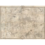
A black and white map of the London area begun in 1741 and completed in 1745 by John Roque, engraved by Richard Parr. It is entitled: An Exact Survey of the Citys of London, Westminster, ye Borough of Southwark, and the Country near Ten Miles round, with the title given in English, Latin and French. The map was originally printed in 16 sheets, and is set within a decorative border. This detailed historic map shows London from Harrow on the Hill and Tottenham Hale in the north to Mitcham Bridge and Penge Common in the south, and from Hounslow, Twickenham and Teddington Commons in the west to Woolwich and Shooter's Hill in the east. Maps.Crace.19.18.
Creator: John Rocque
Small 30cm x 40cm
Medium 45cm x 60cm
Large 60cm x 80cm
Extra large 75cmx 100cm
Please note the sizes above refer to the paper size, the image size will be smaller.
We are able to process UK and international orders for custom prints, with the exception of Europe.
Custom prints are not eligible for free shipping.
UK Orders
|
Custom Print Type |
UK Shipping |
Timescale |
|
Unframed Custom Print |
£8 |
5-7 Business Days |
|
Framed Custom Print |
£12.50 |
21 Business Days* |
North America
Important Notice: Temporary Suspension of U.S. Shipping
|
Custom Print Type |
North American Shipping |
Timescale |
|
Unframed Custom Print |
£20 |
15+ Business Days |
Rest of the World
|
Custom Print Type |
ROW Shipping |
Timescale |
|
Unframed Custom Print |
£25 |
15+ Business Days |
Unframed prints are shipped within 5 working days.
Framed orders are shipped within 20 working days.
As these products are made to order, we do not offer refunds on custom prints unless they are faulty or we have made an error.
For more information about custom prints please visit our FAQ's.